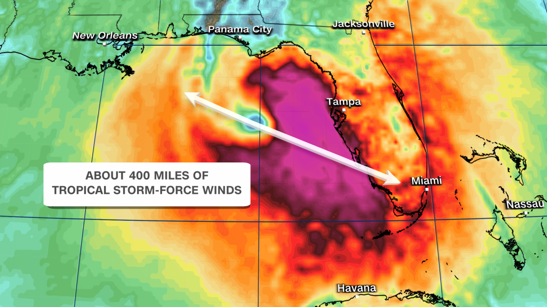
Helene formed in the northwestern Caribbean Sea Tuesday morning and will set off on a breakneck pace of strengthening. It could take Helene just 48 hours to go from a 45 mph tropical storm to a Category 3 major hurricane as it rapidly intensifies over the extremely warm waters of the Gulf of Mexico.
A hurricane warning was issued for parts of Florida’s Gulf Coast, from Anclote River to Mexico Beach, according to the National Hurricane Center’s 11 p.m. ETadvisory. The Mexican government has also issued a hurricane warning from Cabo Catoche to Tulum.
Asof 11 p.m. ET, Helene’s maximum sustained winds had increased to 60 mph with higher gusts, and the storm was on track to make landfall late Thursday on Florida’s Gulf Coast, possibly in the Big Bend region, the hurricane center said.
TRACK THE STORM: See the latest spaghetti models and maps here
Helene’s accelerated timeline means now is the time for Floridians to prepare for damaging winds, flooding rainfall and potentially life-threatening storm surge. There could also be shifts in the storm’s track in the coming days, the National Hurricane Center warned, and that could alter where its worst impacts occur.
The Southeast should prepare, too. Helene will also be exceptionally large and powerful and impact an area far beyond Florida. Torrential rain, strong winds capable of causing significant power outages and the threat of tornadoes will stretch into the region.
Evacuations began Tuesday for some coastal areas of Florida facing potentially dangerous storm surge. Officials ordered mandatory evacuations in parts of at least seven counties, including Pinellas, Hernando, Charlotte, Gulf, Manatee and Sarasota.
Mandatory evacuations have also been ordered for the entirety of Franklin, Wakulla and Taylor counties.
The last hurricane to make landfall in the US as a Category 3 – Idalia – also came ashore in the Big Bend region and generated a record-breaking storm surge from Tampa to the Big Bend in August last year.
Florida and Georgia begin preparations
Florida Gov. Ron DeSantis expanded an emergency declaration from 41 to 61 of the state’s 67 counties Tuesday over the threat of more inland impacts. The declaration helps expedite preparations and coordination between the state and local governments ahead of the storm’s arrival.
At least 3,000 members of the Florida National Guard are ready to assist with storm efforts and the Florida State Guard has been activated, DeSantis confirmed at a news conference Tuesday. Additionally, the state has “hundreds of Starlinks” to deploy in case internet access is lost, according to DeSantis.
The Big Bend area is where Helene is currently projected to come ashore, and it faces the most serious storm surge: up to 15 feet of it is possible.
The storm’s large size and intensity could also drive up to 8 feet of surge in the greater Tampa area and multiple feet of surge in areas farther south. With little time to prepare, Tampa General Hospital began erecting a 10-foot-high flood barrier around the facility Monday because of the storm surge risk.
Officials in neighboring Pinellas County warned hundreds of homes would likely flood with a higher storm surge than in past destructive storms.
“This storm is much larger than Idalia and Eta, and for Idalia, portions of our county had over 4 feet of storm surge and we had over 1,500 homes flooded,” Pinellas County emergency management director Cathie Perkins said in a Tuesday news conference.
“If you experienced flooding for Eta and Idalia and the Christmas storm we had, you’re most likely going to have flooding in your area again.”
A mandatory evacuation order was issued for all residential health care facilities along the coast of St. Petersburg, Florida, as residents brace for Helene, according to Mayor Kenneth Welch, with more evacuation orders expected as the storm nears.
“This is a powerful storm, and the time to prepare is now,” Welch said at a news conference. The mayor also requested residents restrict water use in the coming days to help prepare for storm surge as high as 5 to 8 feet in the area.
Georgia Gov. Brian Kemp also declared a state of emergency due to the storm’s expected impacts later this week.
“As we monitor Tropical Storm Helene’s path and potential impact, I have declared a State of Emergency enabling emergency management teams to prepare for and direct resources well in advance of the storm’s arrival. Stay vigilant and stay safe,” Kemp said on X.
Georgia officials warned residents to prepare for a wind event that will affect all 159 counties throughout the state.
“The old saying in emergency response is – you run from water, you hide from wind,” Georgia Emergency Management and Homeland Security Agency Director James Stallings said in a news conference Tuesday, adding people should ensure their emergency supplies will enable them to be safe for up to 72 hours in case power or water goes out.

Florida could feel tropical storm-force gusts as early as Wednesday afternoon
Tropical storm-force wind gusts could begin as early as Wednesday afternoon for the Florida Keys and spread northward, reaching much of the Peninsula by Thursday morning at the earliest. Hurricane-force wind gusts could follow closely behind for many coastal areas.
The worst wind and rain in the Tampa area could start late Wednesday night. It won’t let up through Thursday evening, with hurricane-force winds possible, according to the National Weather Service in Tampa Bay.
The Tallahassee area will have a few more hours to prepare. Landfall is expected southeast of Tallahassee late Thursday, but the worst conditions will arrive in the city earlier and last throughout the day.
Tropical storm-force winds will spread over more of the Southeast by Thursday evening and, along with soaking rainfall, could bring down trees and trigger widespread power outages.
Heavy rainfall is possible for much of the Southeast starting around midweek, but the most torrential rain will fall Thursday into Friday morning. A level 3 of 4 risk of flooding rain is in place for parts of Florida, Georgia, Alabama and parts of the Carolinas Thursday, according to the Weather Prediction Center.
Widespread rainfall totals of 4 to 8 inches are expected from Florida’s Gulf Coast into parts of Tennessee, the Carolinas and Virginia. Totals could approach a foot in parts of the Florida Panhandle and the southern Appalachians. Much of this rain will fall by Friday for the Gulf Coast, but it’ll be a wet weekend farther north.
This rainfall will occur ahead of a slow-moving cold front fed by deep tropical moisture streaming in from Helene.
It’s a set-up known as a predecessor rain event: heavy rain that occurs several hundred miles to the north of a tropical cyclone. These events can often lead to significant flash flooding, and the weather prediction center also warned mudslides and landslides could occur in the southern Appalachians.
In this case, 2 to 4 inches of rainfall is expected Wednesday into Thursday, from northern Alabama and Georgia northward into eastern Tennessee and western portions of the Carolinas, well before Helene makes landfall in Florida.
A flood watch has been issued for more than 20 million people from Florida through the southern Appalachians.
Helene would be 5th hurricane to hit Florida since 2022
Florida’s Big Bend region seems to be a magnet for hurricanes recently. Hurricane Debby slammed into the region in early August as a Category 1 and recovery efforts are still ongoing as the region braces for another blow.
Last August, Idalia went through a period of rapid intensification over the warm waters of the Gulf of Mexico – with its sustained winds increasing 55 mph over the course of 24 hours.
Helene would be the fourth hurricane to make landfall in the US this year and the fifth hurricane to slam Florida since 2022.
The repeated blows have pushed Florida’s insurance market to the brink, with insurers pulling out of the state because of the increasing risk of extreme weather due to climate change.


