(DS&PL) – The latest forecast is that Milton will make landfall in Sarasota, Florida on the night of October 9 (Eastern time) and last until October 10 because the storm’s speed has slowed down.
Video source: FinanceLancelot/X.
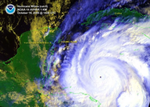
Vietnamplus reported that the US television weather program predicted the devastation of super typhoon Milton with extremely impressive graphics, showing the power of Mother Nature.
Authorities have issued mandatory evacuation warnings across 11 Florida counties, covering about 5.9 million people, according to the Census Bureau. But some residents are determined to stay put.
Hurricane Milton re-strengthened to a powerful Category 5 storm late Wednesday as it churned through the warm waters of the Gulf of Mexico on its way to Florida’s west coast, where mass evacuations clogged freeways as people prepared for what could become a historic storm to make landfall as early as Wednesday night. Some communities, like those in and around the Tampa Bay area, are still grappling with the effects of Hurricane Helene less than two weeks ago.
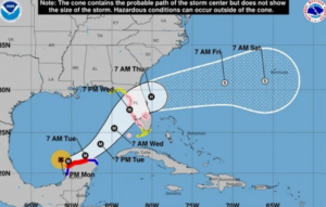
“The storm’s intensity may change as Milton moves through the eastern Gulf of Mexico, but Milton is expected to be a major hurricane when it makes landfall on the west-central Florida coast late Friday,” the National Hurricane Center said .
According to CBS News meteorologist Nikki Nolan, the latest forecast is that Milton will make landfall in Sarasota, Florida on the night of October 9 (Eastern time) and last until October 10 because the storm’s speed has slowed, according to the People’s Representative newspaper.
As Milton strengthened into a Category 5 hurricane (on the US five-point scale) with winds of nearly 180 mph (290 km/h), its strength increased the severity of storm surge forecasts for all coastal areas, including Florida’s Gulf Coast. The eastern side of the eye is considered the “danger side” of the storm, where winds tend to be strongest. As the forecast track shifts north, this side then falls on Tampa Bay, potentially leading to dangerous storm surge conditions in the area.
Additionally, the waters on the Gulf side of Florida are much shallower than the Atlantic side, which can cause storm surges to have a greater impact on communities along the Gulf.
The National Hurricane Center has raised its forecast for storm surge from 8-12 feet to 10-15 feet (3-4.6m), causing rooftop flooding in areas from the Anclote River to Tampa Bay. The severity is expected to increase as the storm’s winds continue to strengthen.
On October 8, President Joe Biden urged Florida residents to evacuate immediately to avoid the storm, warning that the Category 5 storm could become the most serious natural disaster to hit the state in a century. By October 9, US officials said the time for evacuation was over.